Category:Attabad Lake
Jump to navigation
Jump to search
lake in Gilgit-Baltistan, Pakistan  | |||||
| Upload media | |||||
| Instance of | |||||
|---|---|---|---|---|---|
| Location | Gilgit-Baltistan, Pakistan | ||||
| Inception |
| ||||
| Length |
| ||||
| Inflows | |||||
| Outflows | |||||
| Basin country | |||||
 | |||||
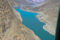
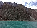
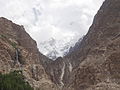
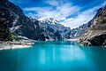
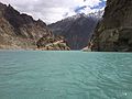
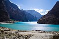
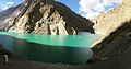
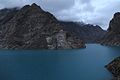
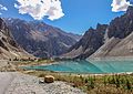
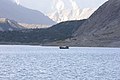
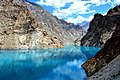
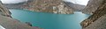
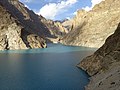
English: Attabad Lake was formed by the blockage of Gupis river by a landslide. Beneath the lake lies a whole entire village including trucks and local residence houses.
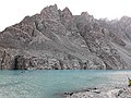
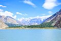
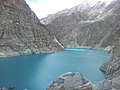
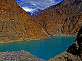
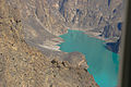
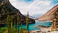
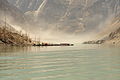
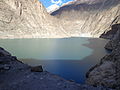
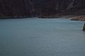
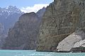
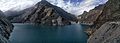
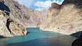
English: “Attabad Lake”, in the valley of Gojal, is created because of water blockage of river Hunza caused by massive land sliding in January 2010. More than 20 people were killed and part of Karakorum Highway was submerged due to this landslide and 6,000 people are displaced from upstream villages. The lake created in this result it is 24 km long, 100meters deep and is at an altitude of 2700 meters, surrounded on all sides by 6000-7000 meter high peaks and glaciers.
Subcategories
This category has the following 16 subcategories, out of 16 total.
A
- Aerial view of Attabad Lake (5 F)
- Aqua Ambulance (3 F)
- Attabad Lake at night (2 F)
- Attabad Lake Boat service (45 F)
- Attabad Lake in winter (5 F)
- Attabad Lake panoramics (3 F)
- Attabad Lake reflections (20 F)
- Attabad tunnel (13 F)
B
G
H
K
P
- Passu Cones (Attabad Lake view) (24 F)
T
- Truck queue at Lake Attabad (4 F)
Media in category "Attabad Lake"
The following 200 files are in this category, out of 383 total.
(previous page) (next page)-
 A bird eye view of Attabad Lake from Borith Lake.JPG 2,816 × 2,112; 2.53 MB
-
 A glimpse of Ataabad lake 02.jpg 4,096 × 3,072; 7.74 MB
-
 A historical valley in gilgit.jpg 960 × 541; 120 KB
-
 A view of Hunza Nagar from Attabad Lake.jpg 5,184 × 3,456; 8.37 MB
-
 Aatabad lake north pak.jpg 2,448 × 3,264; 3.14 MB
-
 Aattabad Lake.jpg 1,152 × 864; 92 KB
-
 Aerial view of Attabad lake.jpg 3,264 × 2,448; 3.43 MB
-
 Ahtabaad Lake view.jpg 3,264 × 2,448; 3.46 MB
-
 Alluvial fans at Attabad Lake.jpg 5,184 × 3,456; 7.57 MB
-
 Amazing Attabad Lake.jpg 5,472 × 3,648; 3.13 MB
-
 Ata Abaad Lake District Hunza GilgitBaltistan.jpg 3,648 × 2,736; 7.68 MB
-
 Ata Abad 15.jpg 5,312 × 2,988; 2.37 MB
-
 Ata Abad 17.jpg 5,208 × 2,868; 1.5 MB
-
 Ata Abad Lake 12.jpg 6,016 × 4,016; 3.05 MB
-
 Ata Abad Lake 2.jpg 6,016 × 4,016; 2.85 MB
-
 Ata Abad Lake 9.jpg 6,016 × 4,016; 3.1 MB
-
 Ata Abad Lake Panoramic.jpg 3,008 × 656; 846 KB
-
 Ata abad lake-01.jpg 5,312 × 2,988; 6.26 MB
-
 Ata abad Lake.JPG 2,592 × 1,944; 1.98 MB
-
 Ata'abad lake.jpg 3,120 × 4,160; 2.34 MB
-
 Ataa Abad lake.jpg 1,280 × 960; 403 KB
-
 Ataabad lake, Hunza, Pakistan.JPG 2,048 × 1,536; 765 KB
-
 Ataabad lake-Hunza.JPG 2,592 × 1,936; 1.96 MB
-
 Ataabad lake.jpg 960 × 720; 108 KB
-
 Ataabad Lake.jpg 4,032 × 3,024; 2.2 MB
-
 Atabaad jheel hunza.jpg 4,128 × 2,322; 4.45 MB
-
 Atababad Lake (Hunza Valley).jpg 5,312 × 2,988; 8.17 MB
-
 Atababad Lake 2.jpg 5,312 × 2,988; 7.39 MB
-
 Atabad jheel, hunza.jpg 1,366 × 2,048; 358 KB
-
 Atabad Lake (19511846716).jpg 2,250 × 1,500; 2.37 MB
-
 Atabad Lake (25526904063).jpg 2,250 × 1,500; 2.39 MB
-
 Atabad Lake (26047570412).jpg 2,249 × 1,500; 2.55 MB
-
 Atabad lake ,hunza, gilgit baltistan,pakistan.jpg 3,264 × 2,448; 2.82 MB
-
 Atabad lake gilgit pakistan.jpg 2,560 × 1,440; 1.58 MB
-
 Atabad lake half way in.JPG 4,608 × 3,456; 3.63 MB
-
 Atabad Lake in hunza.jpg 6,016 × 4,016; 19.04 MB
-
 Atabad Lake near Shiskat (20163008582).jpg 2,250 × 1,500; 3.07 MB
-
 Atabad Lake, Hunza.jpg 1,936 × 2,592; 1.06 MB
-
 Atabad Lake.JPG 1,076 × 720; 268 KB
-
 Atabad.jpg 4,608 × 3,456; 5.68 MB
-
 AtabadLake.jpg 4,928 × 3,264; 5.08 MB
-
 Atta abad lake Hunza PAKISTAN.jpg 3,120 × 4,160; 3.82 MB
-
 Atta Abad lake Hunza Valley Pakistan 2.jpg 3,096 × 4,128; 3.65 MB
-
 Atta Abad Lake, Hunza.jpg 4,126 × 2,468; 2.2 MB
-
 Atta Abad lake.jpeg 720 × 540; 83 KB
-
 Atta abad Lake.jpg 5,183 × 2,604; 1.98 MB
-
 Atta Abad Lake.jpg 5,472 × 3,648; 3.31 MB
-
 Atta abad lake.JPG 4,592 × 2,576; 3.08 MB
-
 Atta'abad Lake.jpg 3,264 × 2,448; 1.3 MB
-
 Attaabad Lake 11.jpg 1,903 × 1,061; 926 KB
-
 Attaabad lake Hunza.JPG 1,632 × 1,224; 855 KB
-
 Attaabad Lake Hunza.JPG 1,632 × 1,224; 821 KB
-
 Attaabad Lake-01.jpg 4,608 × 3,456; 7.91 MB
-
 Attaabad Lake-Hunza.jpg 5,184 × 3,456; 7.74 MB
-
 Attaabad-Lake 1.jpg 4,000 × 3,000; 4.82 MB
-
 Attaabad-Lake.jpg 5,312 × 2,988; 5.74 MB
-
 AttaAbad.jpg 5,184 × 3,456; 6.62 MB
-
 Attaabadlake.JPG 4,288 × 2,848; 4.38 MB
-
 Attabaad Lake Hunza.jpg 6,000 × 4,000; 9.02 MB
-
 Attabaad lake view.jpg 3,104 × 2,328; 1.96 MB
-
 Attabaad Lake, Hunza Valley.jpg 5,248 × 2,952; 11.64 MB
-
 Attabaad lake.jpg 3,264 × 1,836; 2.05 MB
-
 Attababad Lake, Hunza, Gilgit Baltistan, Pakistan.jpg 5,312 × 2,988; 5.85 MB
-
 Attababd Lake Gojal.jpg 4,990 × 3,327; 14.67 MB
-
 Attababd lake.JPG 4,288 × 2,848; 5.25 MB
-
 Attabad & Borit Lake (16603283361).jpg 5,202 × 1,100; 6.43 MB
-
 Attabad 01.jpg 4,000 × 6,000; 4.16 MB
-
 Attabad blue beauty.jpg 1,032 × 581; 83 KB
-
 Attabad Jheel Mountain View.jpg 3,456 × 2,304; 4.27 MB
-
 Attabad Jheel.jpg 3,264 × 1,836; 1.25 MB
-
 Attabad lake (Gojal lake) in Gojal valley.jpg 4,608 × 3,072; 4.76 MB
-
 ATTABAD LAKE (GOJAL).jpg 4,288 × 2,848; 9.14 MB
-
 Attabad Lake , Gojal Valley , Upper Hunza.jpg 3,872 × 2,581; 6.95 MB
-
 Attabad lake , hunza.JPG 4,608 × 3,456; 6.29 MB
-
 Attabad Lake , KKH.jpg 5,184 × 3,456; 11.66 MB
-
 Attabad lake ,shahraheresham.jpg 6,000 × 4,000; 12.5 MB
-
 Attabad Lake - 5th year.JPG 5,184 × 3,456; 7.71 MB
-
 Attabad Lake - Gojal Valley Hunza.jpg 2,272 × 1,704; 832 KB
-
 Attabad Lake - on a boat.jpg 4,928 × 3,264; 7.23 MB
-
 Attabad Lake - Panoramic View.jpg 5,182 × 1,858; 5.05 MB
-
 Attabad Lake -2.jpg 4,320 × 3,240; 5.42 MB
-
 Attabad Lake 01.jpg 6,000 × 4,000; 11.27 MB
-
 Attabad Lake 02.jpg 6,000 × 4,000; 12.23 MB
-
 Attabad Lake 03-09-2015.jpg 3,456 × 2,304; 2.98 MB
-
 Attabad Lake 0410160631e-03.jpg 2,592 × 1,679; 3.33 MB
-
 Attabad Lake 05.jpg 4,542 × 3,180; 4.29 MB
-
 Attabad Lake 1 - Zain.jpg 6,000 × 4,000; 17.11 MB
-
 Attabad Lake 1 KKH.jpg 1,920 × 1,080; 1.32 MB
-
 Attabad lake 1.0.jpg 3,968 × 2,976; 2.66 MB
-
 Attabad Lake 1.JPG 2,592 × 1,944; 2.8 MB
-
 Attabad lake 1.JPG 5,184 × 3,456; 5.38 MB
-
 Attabad Lake 11.JPG 2,592 × 1,944; 2.55 MB
-
 Attabad Lake 14.jpg 2,560 × 1,440; 782 KB
-
 Attabad Lake 2 KKH.jpg 4,088 × 3,066; 9.54 MB
-
 Attabad Lake 2, Hunza, Pakistan.jpg 3,456 × 4,920; 2.12 MB
-
 Attabad lake 2.jpg 3,968 × 2,976; 5.22 MB
-
 Attabad Lake 20.jpg 3,008 × 2,000; 1.51 MB
-
 Attabad Lake 2016-09-03 1.jpg 1,536 × 2,048; 1.04 MB
-
 Attabad Lake 2016-09-03 2.jpg 1,536 × 2,048; 1.09 MB
-
 Attabad Lake 2016-09-03 3.jpg 1,536 × 2,048; 1.13 MB
-
 Attabad Lake 2016-09-03 4.jpg 1,536 × 2,048; 1.28 MB
-
 Attabad Lake 2016-09-03 7.jpg 1,536 × 2,048; 976 KB
-
 Attabad lake 2017.jpg 5,184 × 3,456; 3.55 MB
-
 Attabad Lake 20180511-WA0015.jpg 1,280 × 960; 227 KB
-
 Attabad Lake 20180511-WA0016.jpg 1,280 × 960; 191 KB
-
 Attabad Lake 20180511-WA0018.jpg 1,280 × 960; 266 KB
-
 Attabad Lake 20180511-WA0021.jpg 1,280 × 960; 274 KB
-
 Attabad Lake 2020.jpg 2,049 × 1,536; 1,016 KB
-
 Attabad Lake 23500.jpg 2,643 × 1,982; 793 KB
-
 Attabad lake 3.JPG 2,992 × 2,000; 2.07 MB
-
 Attabad Lake 3.JPG 2,592 × 1,944; 2.25 MB
-
 Attabad Lake 4.JPG 2,592 × 1,944; 2 MB
-
 Attabad Lake 5.JPG 2,592 × 1,944; 2.33 MB
-
 Attabad Lake 6.JPG 2,592 × 1,944; 2.67 MB
-
 Attabad Lake 7.JPG 2,592 × 1,944; 2.89 MB
-
 Attabad lake 75.jpg 5,685 × 3,790; 17.43 MB
-
 Attabad Lake 8.jpg 1,440 × 1,080; 436 KB
-
 Attabad Lake 9.jpg 4,032 × 3,024; 3.76 MB
-
 Attabad lake a view from boat ride.jpg 3,264 × 2,448; 2.53 MB
-
 ATTABAD LAKE AND PASSU CATHIDRAL MOUNTAINS.jpg 4,128 × 2,322; 3.16 MB
-
 Attabad Lake at Dusk.jpg 4,468 × 2,979; 1.21 MB
-
 Attabad Lake Beautiful Color.jpg 5,472 × 3,648; 20.69 MB
-
 Attabad Lake by Jawwad Shamsi.jpg 960 × 1,175; 233 KB
-
 Attabad lake by me.jpg 2,592 × 1,936; 1.72 MB
-
 Attabad lake by Snaz30.jpg 960 × 720; 88 KB
-
 Attabad Lake by Zehra.jpg 1,536 × 2,048; 1.43 MB
-
 Attabad lake daytime.jpg 4,928 × 3,264; 7.13 MB
-
 Attabad Lake DSC -0178.jpg 6,016 × 4,000; 10.87 MB
-
 Attabad Lake DSC 0885-01.jpg 6,000 × 4,000; 8.57 MB
-
 Attabad Lake DSC 1155-01(1).jpg 1,620 × 1,080; 954 KB
-
 Attabad Lake first glace.JPG 4,608 × 3,456; 3.8 MB
-
 Attabad Lake from KKH.jpg 5,312 × 2,988; 5.73 MB
-
 Attabad Lake Full View.jpg 10,318 × 5,804; 5.3 MB
-
 Attabad lake GB.jpg 4,496 × 3,000; 6.65 MB
-
 Attabad Lake Gilgit 1.jpg 4,160 × 3,120; 3.82 MB
-
 Attabad Lake Gilgit Baltistan.jpg 5,184 × 3,456; 8.5 MB
-
 Attabad Lake Gilgit.jpg 5,184 × 3,456; 8.95 MB
-
 Attabad lake Gojal hunza.jpg 7,360 × 4,828; 18.5 MB
-
 Attabad Lake Gojal Valley Pakistan.jpg 4,096 × 2,144; 2.77 MB
-
 Attabad Lake Gojal Valley.jpg 1,920 × 1,280; 952 KB
-
 Attabad lake Gojal valley.jpg 6,000 × 3,817; 2.85 MB
-
 Attabad Lake Gojal valley.jpg 6,000 × 4,000; 9.59 MB
-
 Attabad Lake green.jpg 3,456 × 2,592; 2.67 MB
-
 Attabad Lake Hunza Gilgit Baltistan.jpg 4,962 × 2,900; 9.81 MB
-
 Attabad lake hunza Lake.jpg 4,854 × 3,456; 5.66 MB
-
 Attabad lake Hunza Pakistan.jpg 5,472 × 3,648; 9.04 MB
-
 Attabad lake hunza pakistan.jpg 6,000 × 4,000; 9.58 MB
-
 Attabad Lake in April.jpg 3,024 × 4,032; 2.45 MB
-
 Attabad Lake in Evening.jpg 3,914 × 5,871; 13.93 MB
-
 Attabad lake in Hunza Valley, Gilgit.jpg 4,000 × 6,000; 6.03 MB
-
 Attabad lake in Hunza Valley.jpg 3,000 × 2,000; 1.74 MB
-
 Attabad lake in Hunza.jpg 3,264 × 2,448; 2.73 MB
-
 Attabad Lake in summer.jpg 4,928 × 3,264; 4.48 MB
-
 Attabad lake in summers.jpg 3,600 × 2,700; 4.43 MB
-
 Attabad lake in winter, Hunza.jpg 5,184 × 3,456; 6.25 MB
-
 Attabad Lake Landscape.jpg 4,608 × 3,456; 4.01 MB
-
 Attabad lake night view.jpg 2,048 × 1,250; 596 KB
-
 Attabad Lake Pakistan.jpg 2,816 × 2,112; 2.52 MB
-
 Attabad lake Pakistan.jpg 2,592 × 1,944; 1.65 MB
-
 Attabad Lake Panorama.jpg 2,384 × 656; 573 KB
-
 Attabad Lake Tmp 852-20150927 124739-1004032191.jpg 5,312 × 2,988; 3.7 MB
-
 Attabad Lake Tmp 852-20150927 125511-1584376327.jpg 5,312 × 2,988; 4.51 MB
-
 Attabad Lake Top view.jpg 2,988 × 5,115; 2.55 MB
-
 Attabad Lake upper hunza.jpg 5,184 × 3,456; 1.24 MB
-
 Attabad Lake View 01.jpg 4,128 × 2,322; 2.25 MB
-
 Attabad Lake View 02.jpg 4,128 × 2,322; 2.52 MB
-
 Attabad Lake View 03.jpg 4,128 × 2,322; 2.47 MB
-
 Attabad Lake View 04.jpg 4,128 × 2,322; 2.59 MB
-
 Attabad Lake View 05.jpg 4,128 × 2,322; 2.8 MB
-
 Attabad Lake View by Karakorum Highway 05.jpg 4,608 × 3,456; 6.44 MB
-
 Attabad Lake View by Karakorum Highway 06.jpg 4,608 × 3,456; 6.09 MB
-
 Attabad Lake view from Boat 01.jpg 4,608 × 3,456; 6.13 MB
-
 Attabad Lake view from Boat 03.jpg 4,608 × 3,456; 6.06 MB
-
 Attabad Lake view from Boat 07.jpg 4,608 × 3,456; 5.78 MB
-
 Attabad Lake View from highway.jpg 4,608 × 3,456; 6.28 MB
-
 Attabad Lake view From Karakoram Highway pic 01.jpg 4,160 × 3,120; 4.53 MB
-
 Attabad Lake view From Karakoram Highway pic 02.jpg 4,160 × 3,120; 4.38 MB
-
 Attabad Lake view from the edge.jpg 4,608 × 3,456; 6.42 MB
-
 Attabad Lake view from the Roadside.jpg 3,264 × 2,448; 1.98 MB
-
 Attabad lake view.JPG 6,016 × 4,000; 9.87 MB
-
 Attabad Lake View.jpg 5,707 × 3,795; 4.45 MB
-
 ATTABAD LAKE View.jpg 4,032 × 3,024; 3.4 MB
-
 Attabad Lake with reflections of mountains 1.jpg 1,440 × 2,560; 1.27 MB
-
 Attabad Lake with reflections of mountains.jpg 2,560 × 1,440; 1.07 MB
-
 Attabad Lake with view of mountains 1.jpg 3,024 × 3,780; 3.51 MB
-
 Attabad Lake with view of mountains 3.jpg 1,536 × 2,048; 1.13 MB
-
 Attabad Lake with view of mountains.jpg 960 × 720; 74 KB
-
 Attabad Lake(Gojal Lake).jpg 5,152 × 3,724; 5.83 MB
-
 Attabad lake, A beautiful catastrophe.jpg 4,000 × 2,666; 2.05 MB
-
 Attabad Lake, from Gulmit (16419241679).jpg 5,202 × 1,100; 7.51 MB
-
 Attabad Lake, from Gulmit in Gilgit-Baltistan, Pakistan (16418530900).jpg 4,742 × 1,100; 5.58 MB
-
 Attabad Lake, from the Spillway (16578502806).jpg 5,202 × 1,100; 4.81 MB
-
 Attabad Lake, Gilgit Baltistan, Pakistan.jpg 4,928 × 3,264; 8.63 MB
-
 Attabad lake, Gilgit, Pakistan.jpg 2,592 × 1,456; 1.13 MB
-
 Attabad Lake, Gojal Pakistan.jpg 5,312 × 2,988; 3.68 MB
-
 Attabad Lake, Gojal Valley Hunza.jpg 3,264 × 2,448; 2.68 MB
-
 Attabad Lake, Gojal Valley, Pakistan.jpg 2,448 × 3,264; 2.85 MB
-
 Attabad Lake, Gojal, Pakistan.jpg 5,356 × 3,571; 16.69 MB
-
 Attabad Lake, Gojal.jpg 6,000 × 4,000; 5.29 MB
-
 Attabad Lake, Hunza (2016).jpg 4,928 × 3,264; 12.7 MB


.jpg)


.jpg)
.jpg)
.jpg)


.jpg)


_in_Gojal_valley.jpg)
.jpg)


.jpg)


.jpg)


.jpg)
.jpg)
.jpg)
.jpg)
.jpg)